
A system of City Wayfinding maps changes attitudes and encourages people to walk. Its specially designed pedestrian map helps people understand and navigate the city and its public transport network, while its signs, carefully positioned at decision points, provide relevant information designed to nudge behaviour in a positive, sustainable way. City Wayfinding encourages walking in the following ways:
There are many iconic wayfinding systems, such as Legible London or WalkNYC, for which good design and ubiquitous, consistent use have managed to raise the status of the city they represent. For locals this can provide a sense of pride, such as New York, where WalkNYC was rolled out across all five boroughs, rather than focusing on Manhattan where the tourists are. For visitors and tourists the system showcases what the city has to offer, with obvious benefits for businesses.
Public transport is especially well served by City Wayfinding, as wayfinding maps overlayed with public transport data makes the system easier to understand and accessible to everyone. Almost all public transport journeys, especially those including several modes of transport, involve walking. City Wayfinding joins up the network and is especially useful at multi-modal interchanges, station forecourts, indeed all public transport touch-points.
The City Wayfinding basemap is designed to encourage walking using a deep knowledge of how we understand our surroundings. Theories about ’Legible’ cities were founded by Kevin Lynch in the 1960s in ’The image of the city’. He showed how a city can be broken down into regular patterns, such as paths, edges, districts, nodes and landmarks for better understanding. These topographic features are recognisable in the fabric of the city, so representing them clearly on maps helps us translate what we are seeing on the map into a mental vision of what to expect when we walk around the environment:
WalkNYC clearly denotes paths throughout the city landscape to provide a legible pattern
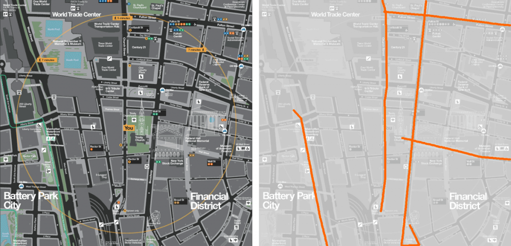
This Toronto TO360 wayfinding map shows how clearly defined edges (here a railway line and highway) help pedestrians understand barriers to walking.
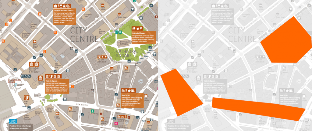
Interconnect Birmingham wayfinding maps clearly denote districts as well defined homogenous areas, helping pedestrians to understand their surroundings
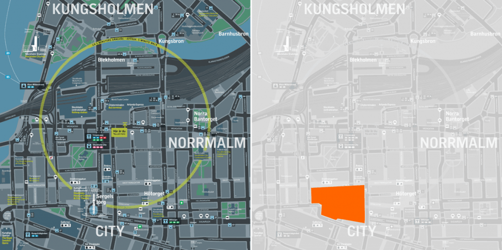
This wayfinding map from Stockholm Regional Transport Authority (SL) shows the concept of using nodes, or hubs, to navigate the city.
Legible London uses landmarks in terms of 3D building illustrations very effectively to provide users with a mental map of the position of prominent landmarks in relation to their current position.
The basemap is layered into a hierarchy of useful information, balancing a copious amount of available data with core data which would be useful for navigation, while still making the map legible. Not least, a walking map should include detail where people are expected to walk and show where pedestrians do not have access.
Showing the right level of detail is linked to cartographic scale. Best practice for City Wayfinding signs is to have two maps complementing each other. One scale is large enough to see detail in pedestrian areas, footpaths and pleasant public spaces, while a smaller overview map provides context in relation to the surrounding area.
The wayfinding basemap is used to make individual signs, which are placed at decision points in an effort to nudge people into choosing to walk. These signs can be designed in order to promote walking in the following ways:
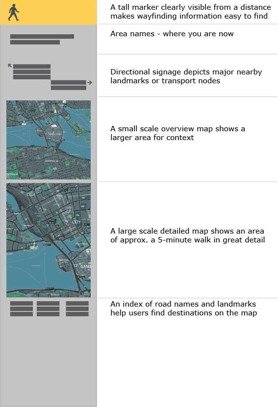
A system of wayfinding signs is positioned as part of a series so that while walking, people are reminded of their journey and confident of finding the next sign along the route. A suite of sign types can be used, providing different amounts of information depending on the space available and the likely stage of a journey. This illustration shows how progressive disclosure ensures that more prominent information is visible from further away (the walking symbol and colour bar at the top), then named directional signage is visible, then the map and table as the user gets closer.
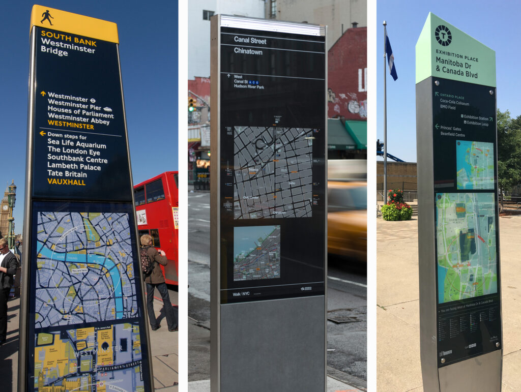
Two scales of mapping are usually necessary to provide: 1) detailed public spaces, pedestrian access, building entrances etc. for roughly 5 minutes walking distance and 2) an overview map showing the context of neighbouring areas and topographic features (such as rivers and lakes) which provide a strong sense of direction.
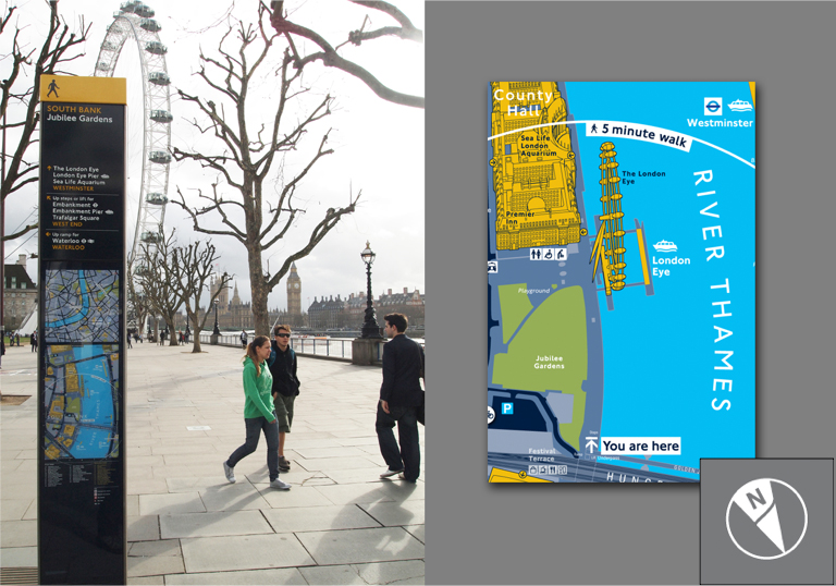
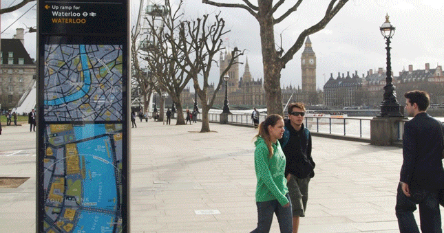
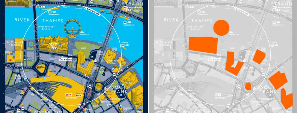
Maps on Wayfinding signs are rotated in the direction of travel – so called ’heads-up’ mapping, rather than conventional North-up. This means that landmarks which are ahead of the sign will appear at the top of the map, such as the London Eye above. On a sign with directional arrows pointing to the left and right, heads-up ensures that this directional information will not contradict with the map.
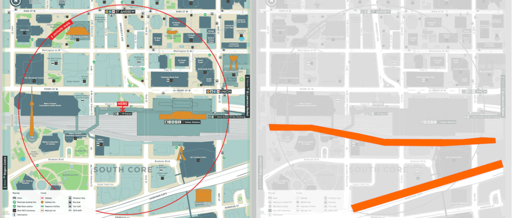
The 5-minute walk circle is an important feature on wayfinding maps to encourage walking by showing that distances which may initially seem to be far are actually only a short walk away.

Illustrating landmark buildings helps to orientate the user by providing a mental image of a building that will be encountered during the walk, or which may already be familiar. The prioritisation of these buildings as landmarks is important for navigation and context, and they are often chosen for their ability to stand out and for being memorable.
In this article we looked at the essentials of City Wayfinding: its benefits and opportunities, what makes mapping legible and the key features of City Wayfinding signage. However, in order to create a successful City Wayfinding system, a strategy must be developed around the overarching information structure, user groups and journeys, touch points and information needs. The strategy will ensure that wayfinding information is coherent and consistent throughout the system. Cities are also unique, and the overall design should take into account the environmental context of the signage.
A wayfinding basemap also requires a thorough development process, where a network of stakeholders are gathered for local input and to establish content selection criteria. The information hierarchy and cartographic design should also reflect the local character and the spirit of the city.
Finally, cartographic accuracy is highly important to Wayfinding systems. City infrastructure and local businesses are in constant flux, and inaccurate maps will lead people to lose faith in the system. Wayfinding should be developed with a maintenance plan in place, so that the maps on nearby signs are kept in sync with each other and with reality. This is especially important in relation to the public transport system, which is also constantly changing.
More about Wayfinding systems and their maintenance can be found here:
Read more about a core GIS for your Wayfinding system
Read more about management of your Wayfinding system
Read more about maintenance of successful Wayfinding systems.